I recently pushed some PHP code to cluster coordinates that helped me cope with hundreds of thousands of geographic locations.
Turns out drawing all of those on a map isn’t that trivial…
It was about time I got around to tidying up & publishing that code. I’m not even sure it is still relevant nowadays, although I assume it still is. I think it’s been about 2 years ago since I worked on this, so if anything I say has drastically changed by now, please let me know!
Problems
I was using Google Maps & was looking for some JavaScript to cluster all of my coordinates: so many individual markers would just be unclear. There were some great clustering scripts out there!
However:
- Hundreds of thousands of locations is a lot to process. It takes a while for all of them to be looped and clustered together.
- If you zoom in/out or pan the map, the markers & clusters need to be redrawn, so they have to be kept in memory in the meantime. This doesn’t scale.
- You have to actually get all of those coordinates to your frontend, either in the HTML source or via an API call. That many makes for a sizable download on slow connections.
As much as the JS clustering tools surprised me with their ability to process lots of markers, they still couldn’t quite handle the amount I was feeding them. And then there was still problem #3.
Strategy
The solution for #3 was obvious: do the clustering in the backend, so we don’t have to transmit that much data to the frontend. Now we only need to feed it the coordinates of the clusters + how many there were, and the leftover (unclustered) coordinates.
Wait a minute, that actually fixes #1 as well!
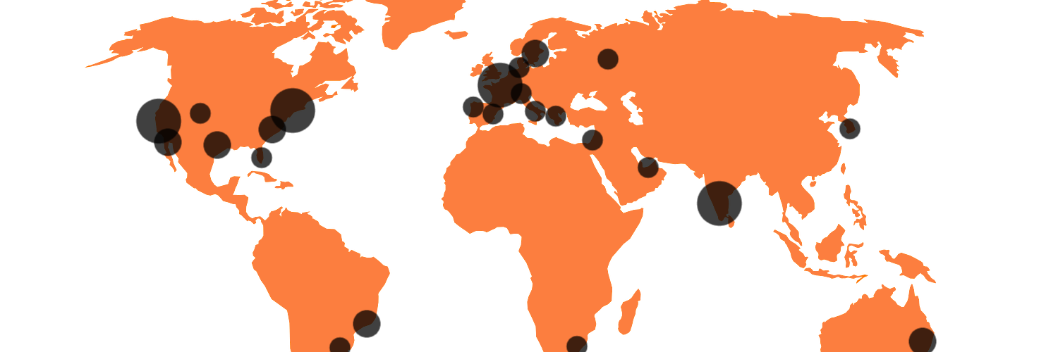
That’s the PHP clusterer I recently pushed. You can give it a viewport & throw a big batch of coordinates at it, and it wil cluster coordinates whenever enough of them are in the same sector of a map.
For scaling reasons, it will not keep any coordinate in memory. As all of them are being processed, the bounds & center of the clusters are immediately adjusted and the coordinate is discarded. No matter how many coordinates you give it, never will it store more than the specified amount of clusters, plus some individual coordinates when there just weren’t enough to cluster.
Conundrum
We didn’t solve #2 yet, though. In fact, we made that one worse: if JS no longer has all locations, it can’t redraw them when we zoom or pan the map.
So… I decided that, when that happens, we just have to re-fetch & re-cluster markers serverside.
I hooked the zoom & pan actions and made sure all previously drawn markers are cleared. Meanwhile, a new API call is launched to fetch markers & clusters within the new viewport.
While that now effectively fixes #2, it also means the API is about to receive a ton of additional calls. Even though the PHP clusterer can handle however many coordinates, it still takes some time to run. Requests would not be completed instantaneously, as you would like.
Cache…
In order to deal with the amount of traffic we’re about to send to the API, and in order to get lightning fast responses, I decided to cache the output.
But what’s there to cache? Every request is different, it’ll be for wildly varying viewports. Yep!
I decided to round the viewports before requesting the coordinates and clusters from the API. Suppose I’m viewing Kortrijk, BE, with a viewport of roughly these coordinates:
(northeast: lat 50.853644, lng 3.298559) to
(southwest: lat 50.806262, lng 3.213587)
The request I would send to the API would be rounded. I would request all markers and clusters for, e.g.:
(northeast: lat 51.000000, lng 3.500000) to
(southwest: lat 50.500000, lng 3.000000)
That would get me too much coordinates & clusters for my viewport, but still a known maximum, which I could easily cache. If I then panned to a neighbouring city, I might just be able to reuse my existing coordinates. Say we move to Waregem, BE: it’s still in the rounded bounds I requested (& cached):
(northeast: lat 50.896700, lng 3.445458) to
(southwest: lat 50.880836, lng 3.422627)
… or don’t
This might look like a lot of cache to you: even when rounded, there’s a lot of sectors you have to cache clustering results for. That’s a lot of cache storage.
Again, you are correct.
However, the zoomed-in viewports were never really a problem. If our maps only covers a very limited ground, we’ll probably only have a couple of markers on there anyway.
The biggest problem was when your viewport covers a lot of ground, like an entire country, continent or even the entire world. Those are the ones we really want to cache!
The more you zoom out, the less “sectors” there will be to cache. In the minimum zoom level, there will only be the entire world. No matter how you pan the map, you’ll always see the entire world. So for the maximum zoom level, we only need to cache 1 requests (coincidentally the most expensive of them all: the one that clusters all coordinates)
As we zoom in, the amount of rounded-down bounds keeps growing, but the importance of caching the result keeps shrinking, as there’ll be fewer and fewer coordinates.